Mount Carleton Provincial Park


Please note, the park closes for a transition period from end of March to mid-May and again from October to January 1. Please contact the park if you are traveling during those times to confirm if we are open.
A challenging mix of Acadian woods and mountain peaks, Mount Carleton has more than 17,000 ha (42,000 acres) of pristine wilderness waiting for today’s explorer. Our habitat is home to more wild animal species than any other part of the province. At least 100 different types of birds and 30 species of mammals live here. A botanist’s eye will also discover a number of rare plants, including Alpine blueberry and Bigelow’s sedge on the slopes of Mount Carleton itself.
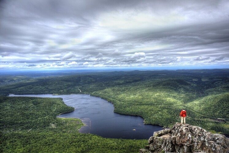
Hiking is a must-do at this provincial park. From a wheelchair-accessible trail at Williams Falls, to challenging mountain hikes, our 11 trails are waiting to be explored. On a clear day, from the top of the Maritimes’ highest mountain, you can see 10 million trees.
• Mount Carleton, 820 m (2,690 ft) the highest peak in the Maritimes
• Mount Head, 792 m (2,589ft) off the beaten track, but worth it!
• Mount Sagamook, 777 m (2,549 ft) our most challenging hike
• Mount Bailey, 564m (1,850 ft) an easier climb and great view.
Designated Dark Sky Preserve by the Royal Astronomical Society of Canada, Mount Carleton Provincial Park is committed to protect and preserve the night sky by reducing light pollution and energy consumption to maintain dark skies and promote star and planet gazing on clear nights.
Camping
Mount Carleton Provincial Park Campground
Mount Carleton Provincial Park is home to 4 different campgrounds for campers at every experience level, plus 2 heritage cabin sites.
Heritage Cabins: Nictau Cabins (Pine, Maple, Cedar, Spruce, Ash, Fir) with capacity ranging from 2-12 people total; Bathurst Cabins (Raccoon, Otter, Beaver, Porcupine, Bear) with capacity ranging from 4-9 people total and mattresses included in all cabins. There is also bathrooms with showers, and a large kitchen. These are common to all people who rent the cabins.
Armstrong Campground: Mount Carleton’s largest campground with 88 sites for trailers and tents. This campground boasts spectacular views of Nictau Lake and Mount Sagamook as well as a pristine beach, washrooms, showers, dry toilets, a kitchen shelter and a dumping station for trailers.
Williams and Franklin Campgrounds: 17 large, secluded tenting sites on both sides of Nictau Lake. Dry toilets, garbage bins and recycling bins are included.
Group Camping: This site can accommodate up to 75 campers and includes a kitchen shelter, garbage and recycling bins and water (hand pump).
Headwaters Campground: For a more extreme camping experience, hike partway up Mount Carleton Trail. There are 4 sites with only pit toilets and tree food storage as on-site amenities.
Lodge-Café: A convenience store is open during camping season for all your camping needs. Enjoy a cup of freshly brewed coffee while surrounded by the serene beauty of nature at the Lode-Café.
Trails
Legend
 Easy
Easy
 Moderate
 Difficult
 Very Difficult
1 - Bald Mountain Brook
Travel through the Bald Mountain Brook valley between the Mount Carleton Plateau and Mount Bailey. Pass by beautiful, large waterfalls and a boardwalk over beaver dams on Bald Mountain Brook.

2 - Caribou Brook
This moderately flat trail travels across a hardwood ridge. The trail drops down towards Caribou Brook (named after the caribou which roamed the mountain until the early 1900s) where you should see plenty of signs of moose before coming out near Bathurst Lake.

3 - Mount Bailey
Travel through mixed forests on your way to the rocky cliffs with views of Mount Sagamook and Mount Carleton. Keep going to the peak for views of Bald Mountain Brook below.
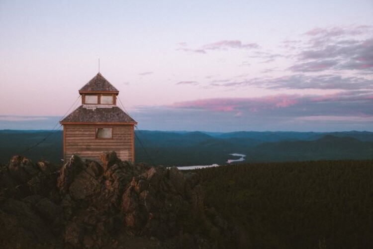
4 - Mount Carleton
The west trail follows a lush, mossy stream up the mountain. Cross a long, rocky ridge to the peak where you will find a tower that marks the highest point in the Maritime provinces. The tower was once used to look for forest fires. The east trail descends along an old access road that passes a fireman's cabin.

5 - Mount Sagamook
Follow the old logging route established by Admiral Spruance, an American sportsman who frequented the park. Rocky outcrops provide iconic views of Nictau Lake and are widely considered the best views of the park. Don’t forget to check out the lookout and ridge on the eastern section for views of Bathurst Lake and surrounding forest.
6 - Mount Head
Mount Head is halfway across the plateau between Mount Sagamook and Mount Carleton. The peak provides the best views of Mount Carleton, Bathurst Lake and Pine Point.
7 - Pine Point
A fire burned through this point of land in 1933 and it regenerated to mostly red pine. Follow along the edge of Bathurst Lake through these red pines before looping back.

8 - Portage
This restored ancient portage trail between the Nictau and Bathurst lakes connected the Saint John River and Nepisiguit River watersheds. It had been used by the Maliseet and Mi’kmaq for centuries and by early explorers and missionaries in the 1700s and early 1900s. The forest trail follows the flattest route between the two lakes, making it one of the easiest in the park.
9 - Williams Falls
Stand on the bridge over the top of the falls or the lookout platform below to see the falls from every angle. A short walk to an amazing place.
10 - Dry Brook
This trail begins at Bathurst Lake and heads west through stands of pine, birch, poplar, maple and spruce. The path follows the brook up the steep-sided valley, passing a number of waterfalls (one of which is 10 metres (32 feet) high). The stream, which headwaters are on the Mount Carleton Plateau, disappears underground in places, earning it the name ‘Dry Brook.'
11 - Big Brook
Embark on a long journey with this trail, beginning at Bathurst Lake and following the shore. You will discover an old fireplace and other remnants of a log cabin built by Buckley, an early Mount Carleton outfitter. The trail then turns inland and follows old logging roads through impressive forests with pristine streams. It joins Mount Carleton Trail just below the ranger cabin.
Current & Upcoming Events
 Jun 22 - Aug 25
Learn to Camp with Parks NB
Learn to camp with Parks New Brunswick returns again this summer!Register Here!We invite families and individuals who have not had the opportunity to learn t...
Location: 20 McGloin St Fredericton